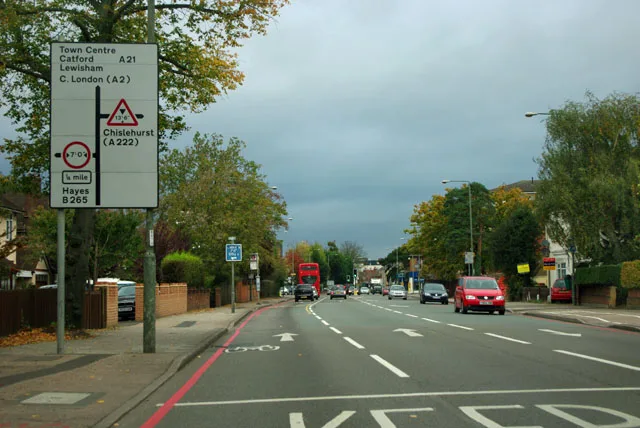

The A21 signals at Cherrycot Hill now run to 2 October and Hayes Road is shut to 25 September. Beckenham Junction closes on Sunday 27 September.
Bromley roadworks come from three different road authorities at once: Transport for London on the red routes, the council on everything else, and the utility companies digging under both. Add a rolling resurfacing programme and the picture gets hard to follow. This page keeps it straight. It covers what is genuinely disrupting traffic now, what is coming in the next fortnight, and the live maps that always have the current answer. It also carries the evergreen facts: who runs which road, and where to park at the stations.
The one to plan for is the railway, not the road. Next Sunday, 27 September, Beckenham Junction, Kent House and Penge East all close, and Lewisham is shut for the whole weekend. On the roads, the A21 signals at Farnborough have been extended again.
What is closed right now (checked 20 September 2026)
Three sets of works are live on borough roads in TfL’s records.
- Hayes Road at Cameron Road, Bromley (BR2). Closed in both directions. Emergency works. TfL logged the closure at 11:00 on Wednesday 27 August and the record still runs to 16:00 on 25 September 2026 (record TIMS-233994). It has not moved in three weeks. TfL says to use another route, with delays possible on the diversion. Hayes Road links Bromley Common and Hayes, so this is a month-long loss of a route plenty of drivers use to avoid the A21.
- A21 Farnborough Way at Cherrycot Hill, Orpington. Two-way temporary traffic signals. Extended again. Last week TfL’s record ended at 16:00 on Friday 18 September. It now runs to 16:00 on 2 October 2026, with the start restamped as 17 September (record TIMS-228867). The lights first went in on 28 May, so this is the second extension we have logged and takes them past four months.
- Mickleham Road at Blythe Hill, St Paul’s Cray (BR5). Closed in both directions for gas works, from 07:00 on Friday 19 September to 22:59 on Monday 21 September 2026 (record TIMS-235139). Three bus routes are diverted around it, listed below.
Gone from the records since last week: the A212 Crystal Palace Parade lane restrictions at Fountain Drive, which were due to end on 18 September.
Source for all of it: TfL’s live road disruption data, which sits behind the TfL traffic status page, read on 20 September 2026.
Buses: three routes are round the Mickleham Road gas works
Road closures show up in the bus network before they show up anywhere else, and TfL’s live disruption list is the fastest way to find a blocked road the council has not announced.
- Routes R5 and R10, Cudham Lane, Orpington. Both terminate and start at Knockholt Pound, Three Horseshoes because the road is closed for UK Power Networks works. Nothing runs through to High Street or Green Street Green. Allow extra time.
- Routes B14, R11 and R1, Mickleham Road, St Paul’s Cray (BR5). B14 and R11 are diverted both ways between Chipperfield Road at Mickleham Road and Midfield Way, via Chipperfield Road. R1 is diverted both ways between St Paul’s Wood Hill at Mickleham Road and Midfield Way, via St Paul’s Wood Hill, and serves no stops on Mickleham Road or Chipperfield Road.
- Route R9 at Gillmans Road, Orpington, is back to normal. The diversion past Tintagel Road, Eldred Drive and Quilter Road has come off TfL’s list.
- Route 336, Churchdown (BR1), diverted towards Catford via Bromley Road, with the road blocked by roadworks. Stops from Glenbow Road to Whitefoot Lane/Bromley Road are not served.
- Route 119 at Hayes Lane is back to normal. The tree-branch diversion via Pickhurst Lane and Westmoreland Road, which ran for more than a week, has come off TfL’s list.
Source: TfL bus disruption data, read on 20 September 2026.
Plaistow Lane: the council still has not said. It closed the road in mid-July after a void was found near the Plaistow Green roundabout, and said then that it hoped to reopen within days (Bromley Council, 13 July). Ten weeks on, that page is word for word unchanged and no reopening notice has appeared in the council’s news feed. What we can say is what the live records show: nothing for Plaistow Lane in TfL’s road disruption data, and no bus diversion for it either. The council’s July statement said buses had to be diverted around the closure. That points to the road being back in use, but the council has not confirmed it and we are not going to say it has. Check the live map below before routing that way.
Resurfacing. The council’s 2026/27 programme still puts three jobs in autumn 2026: Church Hill in Orpington, Homesdale Road between Old Homesdale Road and Page Heath Lane in Bromley Town, and Old Priory Avenue in St Mary Cray. The four principal-road schemes for the year are Anerley Hill and Anerley Road, Court Road (A224) at Chelsfield, the High Street at Green Street Green (A223) and Sevenoaks Way (A224) between Broomwood Road and Leesons Hill (planned carriageway and footway works). The page is unchanged again this week and still gives no exact dates, only seasons. Resurfacing usually means short-dated overnight or off-peak closures, and the dates appear on the signs and the live maps below.
Today, Sunday 20 September: the Hayes line is closed
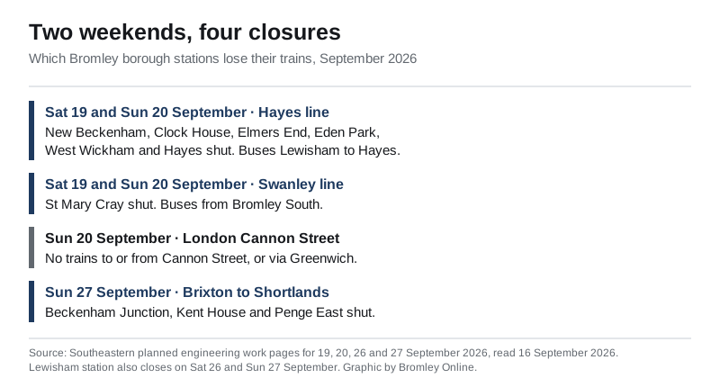
All lines between Ladywell and Hayes are shut for both days, so no trains run between London Charing Cross and Hayes. Six of the nine closed stations are in this borough.
Closed all weekend, replacement buses only:
- New Beckenham
- Clock House
- Elmers End
- Eden Park
- West Wickham
- Hayes
Ladywell, Catford Bridge and Lower Sydenham, on the Lewisham side, close with them.
Accessible replacement buses run between Lewisham and Hayes, calling at all stations and additionally at Beckenham Junction, so you can pick up a Victoria train there rather than riding the bus the whole way (Southeastern, 19 and 20 September).
St Mary Cray closes the same weekend
All lines are also shut between Bickley and Borough Green & Wrotham, and between Bickley and Rochester, on both days. St Mary Cray station is closed all weekend and served by replacement buses only, along with Swanley, Farningham Road, Longfield, Meopham, Sole Street, Eynsford, Shoreham (Kent), Otford, Kemsing and Bat & Ball.
Replacement buses run between:
- Bromley South and Meopham, calling at all stations except Bickley
- Bromley South and Borough Green & Wrotham, calling at Chislehurst, St Mary Cray, Swanley and Otford
- Meopham and Strood, non-stop
What changes for borough passengers:
- Extra trains run between London Victoria and Bromley South via Denmark Hill, Peckham Rye and Nunhead, on both days.
- Thameslink’s Sevenoaks to Blackfriars trains divert via Orpington and call additionally at Orpington and Petts Wood. That is a rare direct link and it is worth knowing about. A replacement bus also runs Sevenoaks to Bromley South via Swanley.
- For Maidstone East, Southeastern says to travel to Chislehurst and change there for the replacement bus. Charing Cross to Maidstone East trains do not run on the Saturday.
- Victoria to Ramsgate and Dover Priory trains run non-stop between Victoria and Strood.
Thameslink between Orpington and Blackfriars via Denmark Hill or Catford is accepted at no extra cost, as is the Underground between Victoria, Charing Cross, Embankment, Cannon Street, London Bridge, Southwark and Waterloo.
Sunday 20 September: Cannon Street shuts as well
No trains run to or from London Cannon Street, or via Greenwich, for the whole day. Cannon Street to Slade Green services are cancelled on both the Woolwich and Bexleyheath routes, with extra Charing Cross to Dartford trains via Woolwich Arsenal instead. St Johns, Deptford, Greenwich, Maze Hill, Westcombe Park and Charlton are closed all day, with buses between Lewisham and Charlton. The Underground is accepted between Cannon Street, Charing Cross, Embankment, Waterloo, Southwark and London Bridge, and the DLR between Lewisham and Greenwich (Southeastern, 20 September).
Next weekend, 26 and 27 September: Beckenham Junction, Kent House and Penge East close
Worth knowing now, because it hits a different half of the borough.
Saturday 26 and Sunday 27 September: Lewisham station closes, along with the Bexleyheath line. Hayes line and Grove Park line trains run but do not call at Lewisham, and neither do Sidcup line trains. Victoria to Dartford and Gravesend trains do not run at all. Buses run New Cross to Dartford via Bexleyheath, calling at all stations (Southeastern, 26 September).
Sunday 27 September: the lines between Brixton and Shortlands close, via Herne Hill and Beckenham Junction. Three borough stations shut for the day and are served by buses only:
- Beckenham Junction
- Kent House
- Penge East
Herne Hill, West Dulwich and Sydenham Hill close with them, and Brixton is shut all day. Victoria to Orpington trains are diverted to call at Denmark Hill and then run non-stop to Shortlands. Accessible buses run between Denmark Hill and Bromley South, calling at all stations via Beckenham Junction except Brixton. The Underground is accepted between Victoria and Brixton (Southeastern, 27 September).
Late nights this week and next
Network Rail works overnight across the region from Monday to Friday. Two items land on the borough.
- Tonight, Wednesday 16 September, from 23:55: accessible buses replace trains between Beckenham Junction and Orpington, calling at all stations. This has run on Monday, Tuesday and Wednesday nights this week.
- Wednesday to Friday, from 00:30: trains towards Orpington and Sevenoaks do not stop at Lewisham. An accessible bus leaves London Bridge at 01:10 and runs to Orpington, calling at all stations (Southeastern, 14 to 18 September).
Next week, from Tuesday 22 to Friday 25 September, buses replace trains between Lewisham and Gravesend via Sidcup from 00:10, with Sidcup line trains diverted via Bexleyheath. Borough passengers get one specific change: the 04:23 Swanley to London Victoria starts from Orpington at 04:26, and an accessible bus runs Swanley to Bromley South at 03:49, calling at St Mary Cray and Bickley (Southeastern, 21 to 25 September).
You may still be owed money. Anyone who normally travels via Charing Cross or Waterloo East and paid more to get in another way during the summer closure can claim it back. Southeastern’s refund form is open until Wednesday 30 September, so there are two weeks left, and you will need receipts. Contactless and Oyster users have to register the card on the TfL Go app to get them (Southeastern).
Our trains guide has the standard timetable pattern.
Driving out: the QEII Bridge closes on Saturday night
National Highways publishes a rolling seven-day closure list. The copy issued at 15:31 on 15 September has one item that should stop anyone driving to Essex late on Saturday.
- Saturday 19 September: the QEII Bridge closes. The clockwise crossing from junction 31 to junction 1A shuts at 21:30 on Saturday until 09:00 on Sunday for bridge maintenance, with a diversion signed on the National Highways network. The Dartford Crossing East Tunnel closes northbound from 21:00, also to 09:00, to run the contraflow, and the report states there is no access over the crossing for vehicles over 4.8 metres high. The M25 clockwise junction 31 entry slip closes from 21:15. In practice the whole crossing is a single bore working both ways for twelve hours.
- The West Tunnel is closed northbound most other nights, roughly 22:00 to 05:30 on Tuesday, Wednesday, Thursday and Monday nights, and 23:00 to 05:30 on Friday.
- A282 southbound, junction 1A to junction 2, closed 23:00 on Friday 18 September to 06:00 on Saturday, for technology works on the QEII Bridge approach.
- A21 northbound, the Westerham Road west exit slip, closed 20:00 to 05:00 on Thursday and Friday nights for Vodafone works. This is the borough’s own road out, just past the Biggin Hill turn.
- A21 northbound, the Sevenoaks exit slip, closed 20:00 to 06:00 on Saturday and Sunday nights. Anyone coming back into the borough from the south that late has to run on to the next junction.
- The A21 further south, Flimwell to Northbridge roundabout, is closed in both directions on Saturday and Sunday nights, 20:00 to 06:00. That is near Hurst Green in East Sussex, about 30 miles beyond the borough boundary, and it affects anyone driving to Hastings after dark rather than anyone driving locally.
Across the whole strategic road network the weekly rhythm is stark:
| Day | Closures listed nationally |
|---|---|
| Tuesday 15 September | 315 |
| Wednesday 16 September | 309 |
| Thursday 17 September | 306 |
| Friday 18 September | 295 |
| Saturday 19 September | 117 |
| Sunday 20 September | 91 |
| Monday 21 September | 321 |
Source: National Highways’ seven-day road closure report, the spreadsheet last updated at 15:31 on 15 September 2026. The file is replaced every day, so the counts above are the ones published when we checked.
Who runs which road
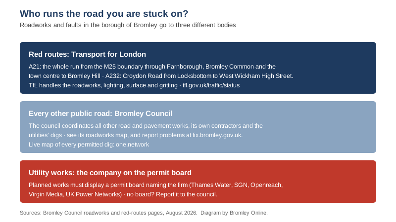
This is the fact that saves the most wasted phone calls. Two of the borough’s biggest roads are not the council’s at all: they are TfL red routes. The council’s own page spells out the boundaries. They are the A21 from the M25 to the Lewisham boundary at Bromley Hill, and the A232 from Locksbottom (Croydon Road) to the boundary with Croydon at West Wickham High Street. On those, TfL is responsible for roadworks, street lighting, road and pavement maintenance and winter gritting (Bromley Council red routes).
Everything else that is a public road is coordinated by the council. It permits and schedules works by its own contractors and by the utilities: Thames Water, Southern Gas Networks, BT Openreach, Virgin Media and UK Power Networks. All planned works must display a permit board naming who is digging and the permit number. Unpermitted works can be reported at fix.bromley.gov.uk (Bromley Council roadworks).
The contractor changed this summer. FM Conway took over the council’s highway maintenance work from 1 July 2026 under three contracts worth an estimated £106 million over their life (Bromley Council). It is the firm that now turns up to a reported pothole, a failed street light or a blocked gully. Full detail is in our report on the contract.
The live maps that always have the answer
Roadworks lists date fast; these do not.
- The council’s roadworks map shows current, planned and live traffic information for the borough, using roadworks.org data (Bromley Council).
- one.network carries every permitted dig in the borough on a live national map (one.network).
- TfL traffic status covers the red routes and everything London-wide (tfl.gov.uk/traffic/status), with Tube and rail status alongside.
- National Highways covers the M25, which brushes the borough’s southern edge at the A21 junction (live travel updates).
Station parking, the evergreen version
If disruption pushes you onto the train, the parking picture at the two town-centre stations does not change often. It is also not what most people assume.
- Bromley South has no station car park (Southeastern). The nearest large option is the council’s 24-hour multi-storey, The Hill on Beckenham Lane, with 340 spaces, pay by RingGo (Bromley Council). The council also runs the ANPR-operated Civic Centre car park off Stockwell Close. Full tariffs are in our parking guide.
- Bromley North has an APCOA car park with about 213 spaces (APCOA). APCOA manages station parking across the Southeastern network (Southeastern).
Frequently asked questions
Are there trains from Hayes to London this weekend?
No. All lines between Ladywell and Hayes are closed on Saturday 19 and Sunday 20 September, so no trains run between London Charing Cross and Hayes. Accessible buses run between Lewisham and Hayes, calling at all stations and additionally at Beckenham Junction for Victoria trains.
Which Bromley stations are closed on 19 and 20 September?
On the Hayes line: New Beckenham, Clock House, Elmers End, Eden Park, West Wickham and Hayes. St Mary Cray is closed the same weekend for separate work between Bickley and Borough Green & Wrotham. Ladywell, Catford Bridge and Lower Sydenham, on the Lewisham side of the Hayes line, are closed too.
Is Beckenham Junction open on Sunday 27 September?
No. Beckenham Junction, Kent House and Penge East are all closed that day while the lines between Brixton and Shortlands are shut. Buses run between Denmark Hill and Bromley South, calling at all stations via Beckenham Junction except Brixton.
Is Hayes Road closed in Bromley?
Yes, in both directions at the junction with Cameron Road, for emergency works. TfL logged the closure on 27 August and the record runs to 16:00 on 25 September 2026. It has not moved in three weeks.
Is the Dartford Crossing closed this weekend?
The QEII Bridge is, on Saturday night. It closes clockwise from 21:30 on 19 September to 09:00 on Sunday for bridge maintenance, and the East Tunnel closes northbound from 21:00 to run the contraflow. National Highways’ report says there is no access over the crossing for vehicles over 4.8 metres high.
Has Plaistow Lane reopened?
Bromley Council has published no reopening notice since it closed the road in July, and its July statement is unchanged. TfL’s live records show no road closure and no bus diversion there, but that is not the council confirming anything. Check the live maps before you rely on it.
Where can I see current roadworks in Bromley?
Two places always have the live answer: the council’s roadworks map and one.network. For the A21 and A232 red routes, check TfL’s traffic status as well.
Who is responsible for the A21 in Bromley?
Transport for London, not the council. The A21 is a red route from the M25 boundary all the way to Bromley Hill, so TfL handles its roadworks, lighting, surfacing and gritting (Bromley Council). The same goes for the A232 between Locksbottom and West Wickham High Street.
How do I report a pothole or unauthorised roadworks in Bromley?
Through the council’s reporting site, fix.bromley.gov.uk, for any road except the two red routes. Legitimate works display a permit board naming the company responsible; works without one are worth reporting. The repair itself is now carried out by FM Conway.
Sources
- TfL road disruption data and TfL traffic status, records TIMS-233994 (Hayes Road at Cameron Road), TIMS-228867 (A21 Farnborough Way) and TIMS-233158 (A212 Crystal Palace Parade), read 16 September 2026
- TfL bus disruption data, read 16 September 2026 (routes R5, R9, R10 and 336)
- Southeastern: planned engineering work for 16 September, 19 September, 20 September, 22 September, 26 September and 27 September
- Southeastern: Charing Cross and Waterloo East closure page (refund form, open to 30 September)
- National Highways: seven-day road closure report, spreadsheet last updated 15:31 on 15 September 2026
- Bromley Council: roadworks and the roadworks map (permits, utilities, coordination)
- Bromley Council: red routes (A21 and A232 boundaries, TfL responsibilities)
- Bromley Council: planned carriageway and footway works (2026/27 resurfacing programme)
- Bromley Council: FM Conway highway maintenance contracts
- Bromley Council: Plaistow Lane closure
- Southeastern: station car parking, the Bromley South station page, APCOA Bromley North and The Hill car park
Roadworks dates change at short notice; the live maps above are the authority on the day. Our other guides cover parking in Bromley, trains to London and Bromley bin collection days. Last checked 16 September 2026.
Have your say