
Bromley's draft air quality plan puts a quarter of the borough's fine particle pollution on home wood burning. The consultation is open until 18 October.
Bromley Council has opened a six-week consultation on how it will tackle air pollution between 2027 and 2031. It runs from 7 September to 18 October 2026 (Bromley Council, 7 September).
The council’s announcement leads on good news. All national air quality objectives are being met in the borough, and nitrogen dioxide has fallen by 46.7% since 2016.
The 71-page draft plan behind it is more candid. It records that the borough’s fine particle pollution has stopped falling, that Bromley will still be over the World Health Organization limit for it in 2030, and that around a quarter of it comes from wood burning in people’s homes (draft Air Quality Action Plan 2027 to 2031).
The number the press release does not carry
Nitrogen dioxide and particulate matter have moved in opposite directions in Bromley over the last decade.
- Nitrogen dioxide (NO2) is down 46.7% since 2016. The plan attributes this mainly to cleaner vehicle exhausts, changes in fleet composition and transport policy.
- PM10 is down 39% since 2016, but concentrations “have plateaued and even increased in the last two years”.
- PM2.5, the finest particles, has plateaued since 2020, and in 2025 “returned to levels observed prior to 2020”.
PM2.5 is the pollutant the plan calls “most strongly associated with long-term public health risk”. Bromley, like every other London borough, is above the WHO guideline for it, and the plan’s own projection is that the borough will still be above it in 2030.
Where the particles come from
The plan uses the 2025 London Atmospheric Emissions Inventory to break down what produces particulate matter in Bromley. Road transport leads on both measures, but the second-largest source of PM2.5 is domestic.
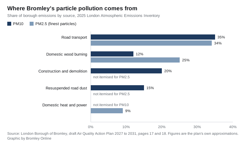
For PM2.5 the plan gives road transport about 34%, domestic wood burning about 25%, and domestic heat and power about 9%. Wood burning here means stoves, open fires and other solid fuel appliances in homes.
For PM10 it gives road transport about 35%, construction and demolition about 20%, resuspension of settled road dust about 15%, and domestic wood burning about 12%.
Nitrogen oxides have shifted too. As traffic emissions have fallen, heat and power generation has become more prominent, and the plan puts it at 41% of the borough’s NOx emissions. That covers gas boilers in homes and businesses as well as standby diesel generators.
Two pollution hotspots, and a bid to delist them
Bromley has two Air Quality Focus Areas, which are locations the Greater London Authority designates where the NO2 limit is at risk of being exceeded and a lot of people are exposed:
- Tweedy Road (A21), Bromley High Street and Widmore Road (A222) in the town centre
- Croydon Road, described in the plan as running “between Elmers End Green and Croydon Road”
The plan says that, given the improvements achieved, “the Council will be working with the GLA to remove these”.
The borough’s wider Air Quality Management Area was first declared for nitrogen dioxide in 2007 and enlarged in 2020. The draft plan describes it two different ways. On page 10 it says the area “covers the whole borough except for Biggin Hill, Darwin and parts of St Mary Cray, St Pauls Cray and Chelsfield”. On page 18, and in the council’s press release, it is “an area encompassing the northern part of the borough” with the same exclusions. Those are not the same thing. The only place the boundary is actually drawn is the map at Figure 4 of the draft.
What the council is proposing to do
The draft sets out actions under five themes: monitoring and statutory duties, emissions from buildings and new development, cleaner transport, public health and awareness, and localised solutions. Ten of them are named as priorities:
- keep the automatic monitoring station at Harwood Avenue and the 32 diffusion tubes across the Air Quality Management Area
- require a Construction Environmental Management Plan for all major developments
- apply Air Quality Neutral guidance to developments
- require adequate and well-located green space and green infrastructure in new developments
- require Construction Logistics Plans and Delivery and Servicing Plans from large developments
- discourage unnecessary engine idling by taxis, coaches and other vehicles
- install residential electric vehicle charge points
- share road space to balance parking against bus journey times, cycling and congestion
- get more schools onto the accredited Travel for Life programme
- plant trees, subject to external funding
The plan also sets two targets for 2031 that go beyond the current legal limits: an annual mean of 30 µg/m³ for NO2 and 10 µg/m³ for PM2.5. The legal objectives today are 40 and 20. The WHO guideline for PM2.5 is 5.
Several of these actions bear on decisions the council takes every week. Construction dust and site machinery are controlled through planning conditions, which you can follow through our Bromley planning applications guide. Two of the borough’s biggest roads are not the council’s to manage at all: the A21 and A232 are TfL red routes, as our roadworks and travel page explains.
What it means for you
If you burn wood at home, this plan is partly about you. A quarter of the borough’s PM2.5 comes from domestic solid fuel burning, and the council’s stated approach is awareness rather than enforcement. It reports raising awareness through the London Wood Burning Project alongside other boroughs. If the consultation produces support for firmer measures, that balance could change.
If you are having building work done, the plan leans on construction. Construction and demolition is about a fifth of PM10 emissions. Three of the ten priority actions are about site machinery, management plans and construction logistics.
The health cost is already counted. The most recent estimate of what air pollution costs local health and care services in Bromley, made in 2019, exceeded £50 million. That covers primary care, secondary care, social care and medications.
How to respond. The survey is at surveymonkey.com/r/XX6Q53V, and the draft plan and consultation page are on the council’s website. It closes on 18 October 2026. Written comments can go to the Pollution Control team, Public Protection and Enforcement, Churchill Court, 2 Westmoreland Road, Bromley BR1 1AS, or by email to ehts.customer@bromley.gov.uk.
What the last plan delivered
The 2020 plan, extended to cover 2026, is the one being replaced. The draft records what it produced:
- more than 6,000 trees planted under the Treemendous programme over four seasons: 1,462 in 2021/22, 1,590 in 2022/23, 1,531 in 2023/24 and 1,585 in 2024/25
- the diffusion tube network increased to 32 tubes, and a PM2.5 monitor installed at Harwood Avenue in 2020
- the highest number of gold accredited Travel for Life schools in London
- more than 700 bikes checked at the council’s Dr Bike sessions over five years
- one electric waste collection vehicle bought in 2025 as a pilot
- home energy advice to 235 households in 2024/25
The plan will be reviewed annually, with progress reported to the Mayor of London in the council’s Annual Status Report.
Sources
- Bromley Council: Have your say on Bromley’s future Air Quality Action Plan, 7 September 2026
- Bromley Council: Air Quality Action Plan (AQAP) 2027 to 2031 Consultation Draft, 71 pages, read 9 September 2026 (emissions splits, focus areas, targets, achievements, health cost)
- Bromley Council: AQAP 2027 to 2031 consultation page and the consultation survey
- Bromley Council: air quality annual status reports
Have your say